In today's fast-changing environmental landscape, the demand for precise and readily accessible data has never been more critical. Satellite technology, with its unparalleled reach and accuracy, stands as a cornerstone in tracking and validating sustainability endeavors. At Orbify, we leverage this formidable technology to deliver state-of-the-art environmental insights, facilitating stakeholders worldwide in meeting regulatory standards and realizing their sustainability objectives with unparalleled clarity and efficiency.
How Satellite Data Supports Compliance with Environmental Regulations
Understanding and adhering to environmental regulations such as the European Green Deal, the EU Deforestation Regulation (EUDR), and other initiatives focused on deforestation, biodiversity conservation, and the circular economy is crucial for organizations committed to sustainable practices. However, the lack of accurate and accessible data often hampers compliance efforts.
A powerful solution to overcome these challenges is satellite imagery. This technology provides a robust means of navigating the complex regulatory landscape by delivering reliable data essential for compliance and informed business decisions. The accuracy and transparency of satellite data are key in combating misreporting and exaggeration in environmental reporting. Such discrepancies can lead to significant consequences, including legal repercussions and a loss of stakeholder trust. Therefore, having access to precise data is critical for companies to meet regulatory demands and maintain the integrity of their sustainability claims.
In addition to being accessible and accurate, satellite data offers unparalleled transparency, a critical element for stakeholders and consumers who are increasingly vigilant about the authenticity of corporate environmental claims. With rising concerns over greenwashing—where companies may misrepresent their environmental efforts—satellite imagery provides an essential layer of verification. This technology reassures consumers and stakeholders of the authenticity and compliance of a company’s environmental initiatives.
This level of transparency not only aids companies in adhering to stringent regulations but also fosters trust and bolsters their reputation among environmentally conscious consumers and investors. By leveraging satellite data, businesses can demonstrate their genuine commitment to sustainability, distinguishing themselves in a marketplace where integrity and transparency are highly valued.
EUDR and UKDR: Leveraging Satellite Data for Robust Compliance
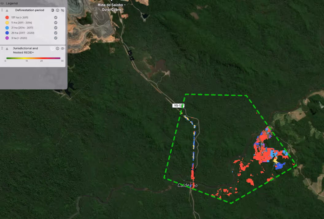
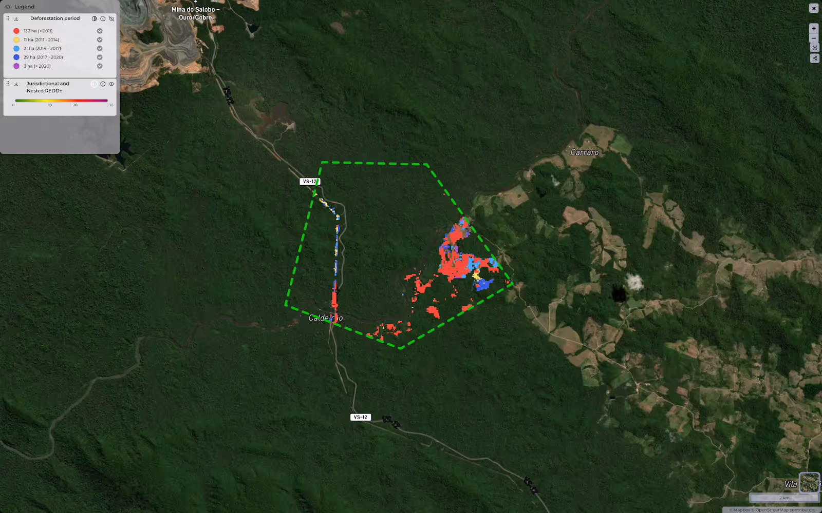
As we delve into regulations and compliance, a prime example is the EU Deforestation Regulation (EUDR) and UK Deforestation Regulation (UKDR), which mandate that traders and operators ensure their products are deforestation-free before entering the EU and UK markets, respectively. Satellite imagery plays a crucial role in fulfilling these geolocation requirements by offering comprehensive monitoring of forest cover changes, including deforestation. Satellite data enhance the ability to assess deforestation risks, facilitating proactive interventions that mitigate environmental impacts and promote sustainable land management practices.
The precision provided by satellite data is vital for organizations dedicated to effectively enforcing environmental laws and regulations. It enables the precise identification and immediate response to unauthorized alterations in landscapes, which are essential for upholding conservation efforts and sustainability commitments. By leveraging such detailed data, companies can ensure compliance with regulations like the EUDR and UKDR while reinforcing their commitment to environmental stewardship.
How does Orbify’s technology benefit me?
Orbify equips organizations with an advanced platform that transforms raw satellite data into actionable environmental insights. Our platform efficiently processes complex satellite imagery, remote sensing data, and field measurements into clear, actionable intelligence. This enables stakeholders of all expertise levels to make informed decisions aligned with legal and sustainability requirements.
Orbify excels in detecting subtle changes in forest density and land use—crucial indicators for monitoring adherence to deforestation and land management laws. This capability not only helps prevent potential legal challenges by addressing non-compliance proactively but also supports organizations in maintaining operational legitimacy in an increasingly eco-conscious regulatory landscape.
Orbify stands as your trusted source for satellite-powered global environmental data, helping ensure that your operations not only meet regulatory standards but also contribute positively to environmental stewardship.
Orbify and iov42 Partnership: Advancing Compliance and Sustainability
Building on our commitment to environmental compliance and sustainability in April 2024, we announced our partnership with iov42. The initial focus is to support organisations to comply with EUDR and other legislation requiring end to end traceability for product legality and sustainability.
By combining Orbify's advanced environmental analytics with iov42's trusted digital identity solution, this partnership is set to offer unmatched accuracy, security, and compliance to organizations globally.
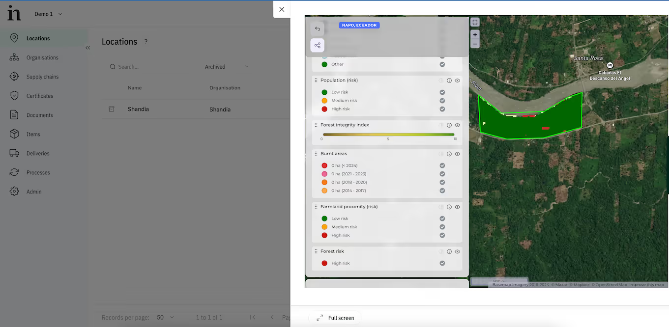
Interu users can utilize Orbify's technology to analyze satellite images and determine the presence of deforestation. This capability allows them to assess deforestation risks, review data on forest integrity, track changes in aboveground biomass, and gain environmental insights from satellite imagery.
The collaboration between Orbify and iov42 stems from successful pilots that integrated Orbify’s deforestation analysis and reporting into Interu through an API. This partnership enhances the availability of detailed and actionable environmental data, enabling users to make well-informed decisions towards a sustainable future.

To wrap things up
Ultimately, by integrating advanced satellite technology, stakeholders can make informed decisions, secure financing, and drive substantial contributions to global climate action. This ensures that their sustainability practices not only meet current regulatory standards but are also well-positioned to adapt to future requirements. Satellite technology, therefore, plays an essential role in enhancing transparency, improving regulatory compliance, and enabling proactive measures to mitigate environmental risks.
Get in touch to learn more!